|
|
|||||||||||||||||
| Point ID: 6651 | Downloads | Plots | Site Data | Code: 9523 |
|
|
|||||||||||||||||
| Download | |
|---|---|
| Site Descriptor Information | Site Time Series Data |
| Link to all available data | |
| View: | Time Series | All |
| Units: | mm |
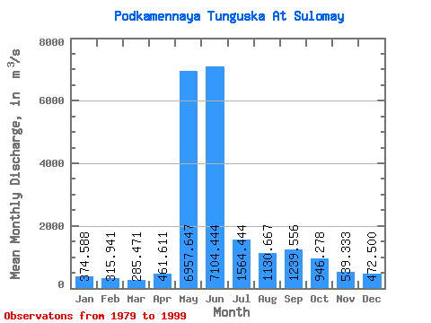
| Statistic | Jan | Feb | Mar | Apr | May | Jun | Jul | Aug | Sep | Oct | Nov | Dec | Annual |
|---|---|---|---|---|---|---|---|---|---|---|---|---|---|
| Mean | 374.59 | 315.94 | 285.47 | 461.61 | 6957.65 | 7104.44 | 1564.44 | 1130.67 | 1239.56 | 946.28 | 539.33 | 472.50 | 1808.38 |
| Standard Deviation | 80.45 | 57.59 | 48.08 | 704.96 | 2023.05 | 3203.16 | 368.90 | 361.31 | 488.99 | 377.17 | 143.88 | 117.25 | 241.82 |
| Min | 271.00 | 232.00 | 205.00 | 222.00 | 3520.00 | 3020.00 | 1110.00 | 639.00 | 625.00 | 410.00 | 329.00 | 305.00 | 1455.83 |
| Max | 525.00 | 436.00 | 375.00 | 3270.00 | 10200.00 | 17300.00 | 2330.00 | 1890.00 | 2290.00 | 1740.00 | 808.00 | 704.00 | 2396.67 |
| Coefficient of Variation | 0.21 | 0.18 | 0.17 | 1.53 | 0.29 | 0.45 | 0.24 | 0.32 | 0.39 | 0.40 | 0.27 | 0.25 | 0.13 |
 Return to R-Arctic Net Home Page