|
|
|||||||||||||||||
| Point ID: 6651 | Downloads | Plots | Site Data | Code: 9523 |
|
|
|||||||||||||||||
| Download | |
|---|---|
| Site Descriptor Information | Site Time Series Data |
| Link to all available data | |
| View: | Time Series | All |
| Units: | m3/s |
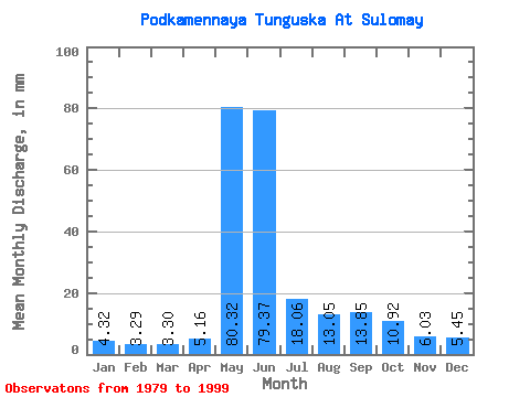
| Statistic | Jan | Feb | Mar | Apr | May | Jun | Jul | Aug | Sep | Oct | Nov | Dec | Annual |
|---|---|---|---|---|---|---|---|---|---|---|---|---|---|
| Mean | 4.32 | 3.32 | 3.29 | 5.16 | 80.31 | 79.37 | 18.06 | 13.05 | 13.85 | 10.92 | 6.03 | 5.45 | 246.00 |
| Standard Deviation | 0.93 | 0.61 | 0.56 | 7.88 | 23.35 | 35.79 | 4.26 | 4.17 | 5.46 | 4.35 | 1.61 | 1.35 | 32.90 |
| Min | 3.13 | 2.44 | 2.37 | 2.48 | 40.63 | 33.74 | 12.81 | 7.38 | 6.98 | 4.73 | 3.68 | 3.52 | 198.04 |
| Max | 6.06 | 4.59 | 4.33 | 36.53 | 117.74 | 193.28 | 26.89 | 21.82 | 25.59 | 20.09 | 9.03 | 8.13 | 326.03 |
| Coefficient of Variation | 0.21 | 0.18 | 0.17 | 1.53 | 0.29 | 0.45 | 0.24 | 0.32 | 0.39 | 0.40 | 0.27 | 0.25 | 0.13 |
 Return to R-Arctic Net Home Page