|
|
|||||||||||||||||
| Point ID: 6647 | Downloads | Plots | Site Data | Code: 9509 |
|
|
|||||||||||||||||
| Download | |
|---|---|
| Site Descriptor Information | Site Time Series Data |
| Link to all available data | |
| View: | Time Series | All |
| Units: | mm |
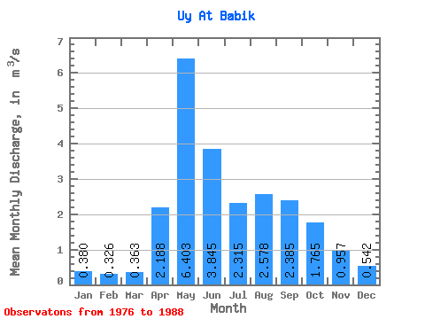
| Statistic | Jan | Feb | Mar | Apr | May | Jun | Jul | Aug | Sep | Oct | Nov | Dec | Annual |
|---|---|---|---|---|---|---|---|---|---|---|---|---|---|
| Mean | 0.38 | 0.33 | 0.36 | 2.19 | 6.40 | 3.84 | 2.31 | 2.58 | 2.38 | 1.77 | 0.96 | 0.54 | 2.01 |
| Standard Deviation | 0.13 | 0.10 | 0.11 | 0.96 | 2.45 | 1.26 | 0.87 | 1.73 | 1.34 | 0.70 | 0.34 | 0.13 | 0.52 |
| Min | 0.16 | 0.14 | 0.20 | 1.25 | 3.87 | 1.73 | 1.15 | 1.35 | 1.44 | 0.78 | 0.49 | 0.34 | 1.45 |
| Max | 0.57 | 0.49 | 0.50 | 4.35 | 11.10 | 6.00 | 3.69 | 6.53 | 5.86 | 2.81 | 1.79 | 0.75 | 3.07 |
| Coefficient of Variation | 0.34 | 0.31 | 0.30 | 0.44 | 0.38 | 0.33 | 0.38 | 0.67 | 0.56 | 0.40 | 0.36 | 0.24 | 0.26 |
 Return to R-Arctic Net Home Page