|
|
|||||||||||||||||
| Point ID: 6647 | Downloads | Plots | Site Data | Code: 9509 |
|
|
|||||||||||||||||
| Download | |
|---|---|
| Site Descriptor Information | Site Time Series Data |
| Link to all available data | |
| View: | Time Series | All |
| Units: | m3/s |
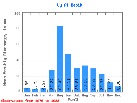
| Statistic | Jan | Feb | Mar | Apr | May | Jun | Jul | Aug | Sep | Oct | Nov | Dec | Annual |
|---|---|---|---|---|---|---|---|---|---|---|---|---|---|
| Mean | 4.89 | 3.82 | 4.68 | 27.27 | 82.44 | 47.91 | 29.81 | 33.19 | 29.73 | 22.73 | 11.93 | 6.97 | 304.31 |
| Standard Deviation | 1.66 | 1.17 | 1.39 | 12.01 | 31.54 | 15.69 | 11.17 | 22.23 | 16.73 | 9.01 | 4.30 | 1.70 | 78.81 |
| Min | 2.06 | 1.64 | 2.58 | 15.58 | 49.83 | 21.56 | 14.81 | 17.38 | 17.95 | 10.04 | 6.11 | 4.38 | 220.51 |
| Max | 7.34 | 5.75 | 6.44 | 54.21 | 142.91 | 74.77 | 47.51 | 84.07 | 73.03 | 36.18 | 22.31 | 9.66 | 465.94 |
| Coefficient of Variation | 0.34 | 0.31 | 0.30 | 0.44 | 0.38 | 0.33 | 0.38 | 0.67 | 0.56 | 0.40 | 0.36 | 0.24 | 0.26 |
 Return to R-Arctic Net Home Page