|
|
|||||||||||||||||
| Point ID: 6641 | Downloads | Plots | Site Data | Code: 9498 |
|
|
|||||||||||||||||
| Download | |
|---|---|
| Site Descriptor Information | Site Time Series Data |
| Link to all available data | |
| View: | Time Series | All |
| Units: | mm |
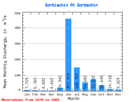
| Statistic | Jan | Feb | Mar | Apr | May | Jun | Jul | Aug | Sep | Oct | Nov | Dec | Annual |
|---|---|---|---|---|---|---|---|---|---|---|---|---|---|
| Mean | 7.71 | 5.76 | 4.83 | 4.66 | 20.94 | 457.00 | 148.75 | 54.68 | 73.58 | 36.65 | 14.02 | 9.33 | 69.99 |
| Standard Deviation | 2.18 | 1.65 | 1.61 | 1.64 | 19.45 | 140.04 | 149.11 | 25.25 | 35.95 | 22.55 | 5.28 | 3.56 | 12.88 |
| Min | 4.69 | 3.08 | 1.67 | 2.07 | 3.03 | 201.00 | 32.30 | 22.30 | 28.50 | 16.40 | 8.01 | 5.47 | 54.69 |
| Max | 12.60 | 7.87 | 7.51 | 7.00 | 56.10 | 657.00 | 449.00 | 97.80 | 130.00 | 95.40 | 24.30 | 18.30 | 89.39 |
| Coefficient of Variation | 0.28 | 0.29 | 0.33 | 0.35 | 0.93 | 0.31 | 1.00 | 0.46 | 0.49 | 0.61 | 0.38 | 0.38 | 0.18 |
 Return to R-Arctic Net Home Page