|
|
|||||||||||||||||
| Point ID: 6641 | Downloads | Plots | Site Data | Code: 9498 |
|
|
|||||||||||||||||
| Download | |
|---|---|
| Site Descriptor Information | Site Time Series Data |
| Link to all available data | |
| View: | Time Series | All |
| Units: | m3/s |
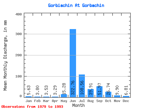
| Statistic | Jan | Feb | Mar | Apr | May | Jun | Jul | Aug | Sep | Oct | Nov | Dec | Annual |
|---|---|---|---|---|---|---|---|---|---|---|---|---|---|
| Mean | 5.62 | 3.83 | 3.53 | 3.29 | 15.28 | 322.76 | 108.54 | 39.90 | 51.97 | 26.74 | 9.90 | 6.81 | 601.84 |
| Standard Deviation | 1.59 | 1.10 | 1.18 | 1.16 | 14.19 | 98.91 | 108.81 | 18.43 | 25.39 | 16.45 | 3.73 | 2.60 | 110.78 |
| Min | 3.42 | 2.05 | 1.22 | 1.46 | 2.21 | 141.96 | 23.57 | 16.27 | 20.13 | 11.97 | 5.66 | 3.99 | 470.30 |
| Max | 9.19 | 5.23 | 5.48 | 4.94 | 40.94 | 464.02 | 327.63 | 71.36 | 91.81 | 69.61 | 17.16 | 13.35 | 768.66 |
| Coefficient of Variation | 0.28 | 0.29 | 0.33 | 0.35 | 0.93 | 0.31 | 1.00 | 0.46 | 0.49 | 0.61 | 0.38 | 0.38 | 0.18 |
 Return to R-Arctic Net Home Page