|
|
|||||||||||||||||
| Point ID: 663 | Downloads | Plots | Site Data | Code: 07BE004 |
|
|
|||||||||||||||||
| Download | |
|---|---|
| Site Descriptor Information | Site Time Series Data |
| Link to all available data | |
| View: | Time Series | All |
| Units: | mm |
| Statistic | Jan | Feb | Mar | Apr | May | Jun | Jul | Aug | Sep | Oct | Nov | Dec | Annual |
|---|---|---|---|---|---|---|---|---|---|---|---|---|---|
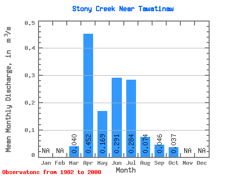
| Mean | 0.04 | 0.45 | 0.17 | 0.29 | 0.28 | 0.07 | 0.05 | 0.04 | |||||
| Standard Deviation | 0.05 | 0.67 | 0.22 | 0.56 | 0.37 | 0.09 | 0.07 | 0.03 | |||||
| Min | 0.00 | 0.04 | 0.01 | 0.01 | 0.00 | 0.00 | 0.00 | 0.00 | |||||
| Max | 0.21 | 2.90 | 0.96 | 2.45 | 1.36 | 0.35 | 0.22 | 0.13 | |||||
| Coefficient of Variation | 1.23 | 1.48 | 1.31 | 1.91 | 1.29 | 1.26 | 1.50 | 0.91 |
 Return to R-Arctic Net Home Page