|
|
|||||||||||||||||
| Point ID: 663 | Downloads | Plots | Site Data | Code: 07BE004 |
|
|
|||||||||||||||||
| Download | |
|---|---|
| Site Descriptor Information | Site Time Series Data |
| Link to all available data | |
| View: | Time Series | All |
| Units: | m3/s |
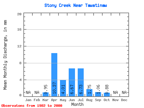
| Statistic | Jan | Feb | Mar | Apr | May | Jun | Jul | Aug | Sep | Oct | Nov | Dec | Annual |
|---|---|---|---|---|---|---|---|---|---|---|---|---|---|
| Mean | 0.84 | 9.16 | 3.54 | 5.89 | 5.95 | 1.55 | 0.93 | 0.77 | |||||
| Standard Deviation | 1.03 | 13.52 | 4.64 | 11.27 | 7.67 | 1.95 | 1.40 | 0.70 | |||||
| Min | 0.02 | 0.83 | 0.23 | 0.16 | 0.08 | 0.04 | 0.02 | 0.06 | |||||
| Max | 4.43 | 58.73 | 20.00 | 49.61 | 28.45 | 7.32 | 4.37 | 2.72 | |||||
| Coefficient of Variation | 1.23 | 1.48 | 1.31 | 1.91 | 1.29 | 1.26 | 1.50 | 0.91 |
 Return to R-Arctic Net Home Page