|
|
|||||||||||||||||
| Point ID: 6605 | Downloads | Plots | Site Data | Code: 9370 |
|
|
|||||||||||||||||
| Download | |
|---|---|
| Site Descriptor Information | Site Time Series Data |
| Link to all available data | |
| View: | Time Series | All |
| Units: | mm |
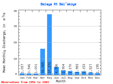
| Statistic | Jan | Feb | Mar | Apr | May | Jun | Jul | Aug | Sep | Oct | Nov | Dec | Annual |
|---|---|---|---|---|---|---|---|---|---|---|---|---|---|
| Mean | 1.06 | 0.95 | 1.00 | 16.07 | 37.37 | 4.99 | 2.90 | 2.37 | 1.98 | 2.15 | 1.53 | 1.20 | 6.11 |
| Standard Deviation | 0.31 | 0.28 | 0.39 | 16.48 | 20.84 | 2.58 | 4.38 | 2.78 | 1.04 | 0.94 | 0.51 | 0.32 | 1.79 |
| Min | 0.62 | 0.57 | 0.48 | 0.83 | 5.41 | 1.61 | 1.15 | 0.84 | 0.79 | 1.03 | 0.85 | 0.72 | 3.04 |
| Max | 1.87 | 1.63 | 2.80 | 54.60 | 78.80 | 11.90 | 27.40 | 16.50 | 6.88 | 5.62 | 3.22 | 2.16 | 11.45 |
| Coefficient of Variation | 0.29 | 0.29 | 0.39 | 1.03 | 0.56 | 0.52 | 1.51 | 1.17 | 0.52 | 0.43 | 0.34 | 0.27 | 0.29 |
 Return to R-Arctic Net Home Page