|
|
|||||||||||||||||
| Point ID: 6605 | Downloads | Plots | Site Data | Code: 9370 |
|
|
|||||||||||||||||
| Download | |
|---|---|
| Site Descriptor Information | Site Time Series Data |
| Link to all available data | |
| View: | Time Series | All |
| Units: | m3/s |
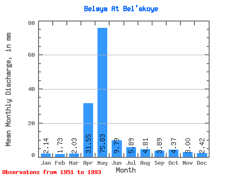
| Statistic | Jan | Feb | Mar | Apr | May | Jun | Jul | Aug | Sep | Oct | Nov | Dec | Annual |
|---|---|---|---|---|---|---|---|---|---|---|---|---|---|
| Mean | 2.15 | 1.75 | 2.03 | 31.55 | 75.81 | 9.79 | 5.89 | 4.81 | 3.89 | 4.37 | 3.00 | 2.42 | 146.16 |
| Standard Deviation | 0.63 | 0.51 | 0.80 | 32.36 | 42.28 | 5.07 | 8.88 | 5.63 | 2.04 | 1.90 | 1.01 | 0.66 | 42.72 |
| Min | 1.26 | 1.05 | 0.97 | 1.63 | 10.98 | 3.16 | 2.33 | 1.70 | 1.55 | 2.09 | 1.67 | 1.46 | 72.68 |
| Max | 3.79 | 3.01 | 5.68 | 107.22 | 159.87 | 23.37 | 55.59 | 33.48 | 13.51 | 11.40 | 6.32 | 4.38 | 273.74 |
| Coefficient of Variation | 0.29 | 0.29 | 0.39 | 1.03 | 0.56 | 0.52 | 1.51 | 1.17 | 0.52 | 0.43 | 0.34 | 0.27 | 0.29 |
 Return to R-Arctic Net Home Page