|
|
|||||||||||||||||
| Point ID: 6575 | Downloads | Plots | Site Data | Code: 9237 |
|
|
|||||||||||||||||
| Download | |
|---|---|
| Site Descriptor Information | Site Time Series Data |
| Link to all available data | |
| View: | Time Series | All |
| Units: | mm |
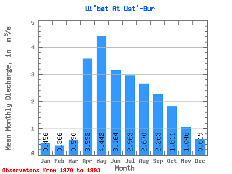
| Statistic | Jan | Feb | Mar | Apr | May | Jun | Jul | Aug | Sep | Oct | Nov | Dec | Annual |
|---|---|---|---|---|---|---|---|---|---|---|---|---|---|
| Mean | 0.46 | 0.37 | 0.59 | 3.59 | 4.44 | 3.16 | 2.96 | 2.67 | 2.26 | 1.81 | 1.05 | 0.62 | 2.00 |
| Standard Deviation | 0.38 | 0.30 | 0.39 | 1.03 | 1.29 | 0.81 | 1.34 | 1.19 | 0.79 | 0.67 | 0.45 | 0.46 | 0.50 |
| Min | 0.06 | 0.07 | 0.11 | 1.90 | 2.98 | 1.90 | 1.69 | 1.49 | 1.40 | 1.04 | 0.37 | 0.16 | 1.30 |
| Max | 1.26 | 1.14 | 1.53 | 6.34 | 8.26 | 5.66 | 7.84 | 6.14 | 4.42 | 3.68 | 2.08 | 1.76 | 3.06 |
| Coefficient of Variation | 0.83 | 0.82 | 0.67 | 0.29 | 0.29 | 0.26 | 0.45 | 0.45 | 0.35 | 0.37 | 0.43 | 0.74 | 0.25 |
 Return to R-Arctic Net Home Page