|
|
|||||||||||||||||
| Point ID: 6575 | Downloads | Plots | Site Data | Code: 9237 |
|
|
|||||||||||||||||
| Download | |
|---|---|
| Site Descriptor Information | Site Time Series Data |
| Link to all available data | |
| View: | Time Series | All |
| Units: | m3/s |
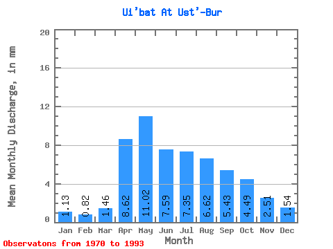
| Statistic | Jan | Feb | Mar | Apr | May | Jun | Jul | Aug | Sep | Oct | Nov | Dec | Annual |
|---|---|---|---|---|---|---|---|---|---|---|---|---|---|
| Mean | 1.13 | 0.83 | 1.46 | 8.62 | 11.02 | 7.59 | 7.35 | 6.62 | 5.43 | 4.49 | 2.51 | 1.53 | 58.36 |
| Standard Deviation | 0.94 | 0.68 | 0.98 | 2.48 | 3.20 | 1.94 | 3.32 | 2.95 | 1.90 | 1.66 | 1.07 | 1.14 | 14.59 |
| Min | 0.15 | 0.17 | 0.27 | 4.56 | 7.39 | 4.56 | 4.19 | 3.69 | 3.36 | 2.58 | 0.89 | 0.40 | 38.02 |
| Max | 3.12 | 2.58 | 3.79 | 15.22 | 20.48 | 13.58 | 19.44 | 15.22 | 10.61 | 9.12 | 4.99 | 4.36 | 89.30 |
| Coefficient of Variation | 0.83 | 0.82 | 0.67 | 0.29 | 0.29 | 0.26 | 0.45 | 0.45 | 0.35 | 0.37 | 0.43 | 0.74 | 0.25 |
 Return to R-Arctic Net Home Page