|
|
|||||||||||||||||
| Point ID: 657 | Downloads | Plots | Site Data | Code: 07BC003 |
|
|
|||||||||||||||||
| Download | |
|---|---|
| Site Descriptor Information | Site Time Series Data |
| Link to all available data | |
| View: | Time Series | All |
| Units: | mm |
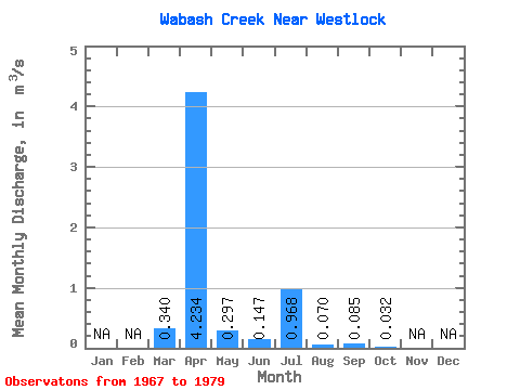
| Statistic | Jan | Feb | Mar | Apr | May | Jun | Jul | Aug | Sep | Oct | Nov | Dec | Annual |
|---|---|---|---|---|---|---|---|---|---|---|---|---|---|
| Mean | 0.34 | 4.23 | 0.30 | 0.15 | 0.97 | 0.07 | 0.09 | 0.03 | |||||
| Standard Deviation | 0.53 | 3.96 | 0.39 | 0.28 | 1.88 | 0.11 | 0.16 | 0.08 | |||||
| Min | 0.00 | 0.12 | 0.01 | 0.00 | 0.00 | 0.00 | 0.00 | 0.00 | |||||
| Max | 1.74 | 14.60 | 1.18 | 1.04 | 6.27 | 0.37 | 0.42 | 0.28 | |||||
| Coefficient of Variation | 1.55 | 0.94 | 1.30 | 1.93 | 1.94 | 1.52 | 1.88 | 2.48 |
 Return to R-Arctic Net Home Page