|
|
|||||||||||||||||
| Point ID: 657 | Downloads | Plots | Site Data | Code: 07BC003 |
|
|
|||||||||||||||||
| Download | |
|---|---|
| Site Descriptor Information | Site Time Series Data |
| Link to all available data | |
| View: | Time Series | All |
| Units: | m3/s |
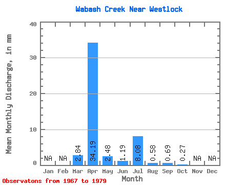
| Statistic | Jan | Feb | Mar | Apr | May | Jun | Jul | Aug | Sep | Oct | Nov | Dec | Annual |
|---|---|---|---|---|---|---|---|---|---|---|---|---|---|
| Mean | 2.83 | 34.19 | 2.48 | 1.19 | 8.08 | 0.58 | 0.69 | 0.26 | |||||
| Standard Deviation | 4.40 | 31.98 | 3.22 | 2.29 | 15.71 | 0.89 | 1.29 | 0.65 | |||||
| Min | 0.00 | 0.95 | 0.07 | 0.03 | 0.00 | 0.00 | 0.00 | 0.00 | |||||
| Max | 14.52 | 117.89 | 9.84 | 8.40 | 52.31 | 3.10 | 3.38 | 2.31 | |||||
| Coefficient of Variation | 1.55 | 0.94 | 1.30 | 1.93 | 1.94 | 1.52 | 1.88 | 2.48 |
 Return to R-Arctic Net Home Page