|
|
|||||||||||||||||
| Point ID: 6542 | Downloads | Plots | Site Data | Other Close Sites | Code: 9049 |
|
|
|||||||||||||||||
| Download | |
|---|---|
| Site Descriptor Information | Site Time Series Data |
| Link to all available data | |
| View: | Time Series | All |
| Units: | mm |
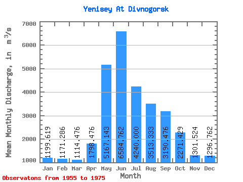
| Statistic | Jan | Feb | Mar | Apr | May | Jun | Jul | Aug | Sep | Oct | Nov | Dec | Annual |
|---|---|---|---|---|---|---|---|---|---|---|---|---|---|
| Mean | 1199.62 | 1171.29 | 1114.48 | 1798.48 | 5167.14 | 6584.76 | 4240.00 | 3513.33 | 3190.48 | 2271.43 | 1301.52 | 1296.76 | 2737.44 |
| Standard Deviation | 833.88 | 939.26 | 895.78 | 817.28 | 2101.98 | 3475.93 | 1318.82 | 868.16 | 670.83 | 383.77 | 563.59 | 858.20 | 431.05 |
| Min | 529.00 | 450.00 | 391.00 | 798.00 | 2350.00 | 2540.00 | 2400.00 | 2500.00 | 2410.00 | 1810.00 | 600.00 | 408.00 | 2120.00 |
| Max | 2870.00 | 3100.00 | 3080.00 | 4130.00 | 8900.00 | 16200.00 | 6520.00 | 5220.00 | 4950.00 | 3170.00 | 2360.00 | 2720.00 | 3747.50 |
| Coefficient of Variation | 0.69 | 0.80 | 0.80 | 0.45 | 0.41 | 0.53 | 0.31 | 0.25 | 0.21 | 0.17 | 0.43 | 0.66 | 0.16 |
| Other Close Sites | ||||||
|---|---|---|---|---|---|---|
| PointID | Latitude | Longitude | Drainage Area | Source | Name | |
| 6541 | "Yenisey At Krysnoyarskaya GES" | 55.46 | 151815 | SHI | 2502.00 | |
 Return to R-Arctic Net Home Page