|
|
|||||||||||||||||
| Point ID: 6542 | Downloads | Plots | Site Data | Other Close Sites | Code: 9049 |
|
|
|||||||||||||||||
| Download | |
|---|---|
| Site Descriptor Information | Site Time Series Data |
| Link to all available data | |
| View: | Time Series | All |
| Units: | m3/s |
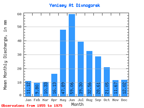
| Statistic | Jan | Feb | Mar | Apr | May | Jun | Jul | Aug | Sep | Oct | Nov | Dec | Annual |
|---|---|---|---|---|---|---|---|---|---|---|---|---|---|
| Mean | 11.12 | 9.89 | 10.33 | 16.13 | 47.88 | 59.06 | 39.29 | 32.56 | 28.61 | 21.05 | 11.67 | 12.02 | 298.94 |
| Standard Deviation | 7.73 | 7.93 | 8.30 | 7.33 | 19.48 | 31.18 | 12.22 | 8.04 | 6.02 | 3.56 | 5.05 | 7.95 | 47.07 |
| Min | 4.90 | 3.80 | 3.62 | 7.16 | 21.78 | 22.78 | 22.24 | 23.17 | 21.61 | 16.77 | 5.38 | 3.78 | 231.51 |
| Max | 26.59 | 26.17 | 28.54 | 37.04 | 82.47 | 145.30 | 60.42 | 48.37 | 44.40 | 29.38 | 21.17 | 25.20 | 409.24 |
| Coefficient of Variation | 0.69 | 0.80 | 0.80 | 0.45 | 0.41 | 0.53 | 0.31 | 0.25 | 0.21 | 0.17 | 0.43 | 0.66 | 0.16 |
| Other Close Sites | ||||||
|---|---|---|---|---|---|---|
| PointID | Latitude | Longitude | Drainage Area | Source | Name | |
| 6541 | "Yenisey At Krysnoyarskaya GES" | 55.46 | 151815 | SHI | 2502.00 | |
 Return to R-Arctic Net Home Page