|
|
|||||||||||||||||
| Point ID: 6538 | Downloads | Plots | Site Data | Code: 9006 |
|
|
|||||||||||||||||
| Download | |
|---|---|
| Site Descriptor Information | Site Time Series Data |
| Link to all available data | |
| View: | Time Series | All |
| Units: | mm |
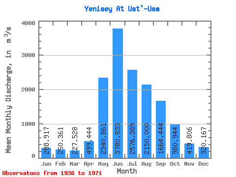
| Statistic | Jan | Feb | Mar | Apr | May | Jun | Jul | Aug | Sep | Oct | Nov | Dec | Annual |
|---|---|---|---|---|---|---|---|---|---|---|---|---|---|
| Mean | 288.92 | 250.36 | 227.53 | 499.44 | 2340.86 | 3780.83 | 2576.39 | 2150.00 | 1664.44 | 980.94 | 419.81 | 320.17 | 1291.64 |
| Standard Deviation | 38.91 | 34.97 | 33.62 | 263.43 | 627.19 | 1096.06 | 731.21 | 451.92 | 305.15 | 182.68 | 76.25 | 44.06 | 191.55 |
| Min | 218.00 | 192.00 | 169.00 | 212.00 | 641.00 | 1800.00 | 1310.00 | 1440.00 | 1070.00 | 703.00 | 287.00 | 234.00 | 992.67 |
| Max | 386.00 | 340.00 | 317.00 | 1480.00 | 3520.00 | 6770.00 | 4420.00 | 3190.00 | 2580.00 | 1580.00 | 573.00 | 406.00 | 1710.58 |
| Coefficient of Variation | 0.14 | 0.14 | 0.15 | 0.53 | 0.27 | 0.29 | 0.28 | 0.21 | 0.18 | 0.19 | 0.18 | 0.14 | 0.15 |
 Return to R-Arctic Net Home Page