|
|
|||||||||||||||||
| Point ID: 6538 | Downloads | Plots | Site Data | Code: 9006 |
|
|
|||||||||||||||||
| Download | |
|---|---|
| Site Descriptor Information | Site Time Series Data |
| Link to all available data | |
| View: | Time Series | All |
| Units: | m3/s |
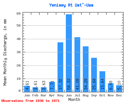
| Statistic | Jan | Feb | Mar | Apr | May | Jun | Jul | Aug | Sep | Oct | Nov | Dec | Annual |
|---|---|---|---|---|---|---|---|---|---|---|---|---|---|
| Mean | 4.61 | 3.64 | 3.63 | 7.71 | 37.31 | 58.33 | 41.07 | 34.27 | 25.68 | 15.64 | 6.48 | 5.10 | 242.64 |
| Standard Deviation | 0.62 | 0.51 | 0.54 | 4.06 | 10.00 | 16.91 | 11.66 | 7.20 | 4.71 | 2.91 | 1.18 | 0.70 | 35.98 |
| Min | 3.48 | 2.79 | 2.69 | 3.27 | 10.22 | 27.77 | 20.88 | 22.95 | 16.51 | 11.21 | 4.43 | 3.73 | 186.48 |
| Max | 6.15 | 4.94 | 5.05 | 22.83 | 56.11 | 104.45 | 70.46 | 50.85 | 39.81 | 25.19 | 8.84 | 6.47 | 321.35 |
| Coefficient of Variation | 0.14 | 0.14 | 0.15 | 0.53 | 0.27 | 0.29 | 0.28 | 0.21 | 0.18 | 0.19 | 0.18 | 0.14 | 0.15 |
 Return to R-Arctic Net Home Page