|
|
|||||||||||||||||
| Point ID: 6534 | Downloads | Plots | Site Data | Code: 8391 |
|
|
|||||||||||||||||
| Download | |
|---|---|
| Site Descriptor Information | Site Time Series Data |
| Link to all available data | |
| View: | Time Series | All |
| Units: | mm |
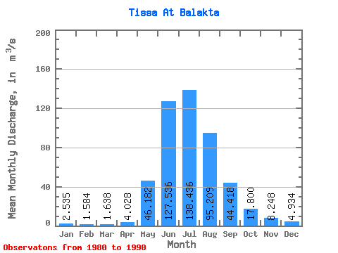
| Statistic | Jan | Feb | Mar | Apr | May | Jun | Jul | Aug | Sep | Oct | Nov | Dec | Annual |
|---|---|---|---|---|---|---|---|---|---|---|---|---|---|
| Mean | 2.54 | 1.58 | 1.64 | 4.03 | 46.18 | 127.54 | 138.44 | 95.21 | 44.42 | 17.80 | 8.25 | 4.93 | 41.05 |
| Standard Deviation | 0.75 | 0.57 | 0.67 | 2.39 | 13.48 | 39.26 | 32.52 | 23.74 | 12.69 | 3.21 | 2.50 | 1.33 | 6.48 |
| Min | 1.68 | 0.80 | 1.04 | 1.37 | 21.50 | 64.80 | 83.80 | 70.80 | 27.90 | 12.20 | 5.28 | 2.55 | 30.32 |
| Max | 4.29 | 2.74 | 3.38 | 9.74 | 59.40 | 210.00 | 186.00 | 132.00 | 65.80 | 23.70 | 12.80 | 7.95 | 51.79 |
| Coefficient of Variation | 0.29 | 0.36 | 0.41 | 0.59 | 0.29 | 0.31 | 0.23 | 0.25 | 0.29 | 0.18 | 0.30 | 0.27 | 0.16 |
 Return to R-Arctic Net Home Page