|
|
|||||||||||||||||
| Point ID: 6534 | Downloads | Plots | Site Data | Code: 8391 |
|
|
|||||||||||||||||
| Download | |
|---|---|
| Site Descriptor Information | Site Time Series Data |
| Link to all available data | |
| View: | Time Series | All |
| Units: | m3/s |
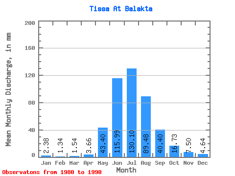
| Statistic | Jan | Feb | Mar | Apr | May | Jun | Jul | Aug | Sep | Oct | Nov | Dec | Annual |
|---|---|---|---|---|---|---|---|---|---|---|---|---|---|
| Mean | 2.38 | 1.36 | 1.54 | 3.66 | 43.40 | 115.99 | 130.08 | 89.46 | 40.40 | 16.73 | 7.50 | 4.64 | 454.53 |
| Standard Deviation | 0.70 | 0.49 | 0.63 | 2.17 | 12.67 | 35.71 | 30.56 | 22.30 | 11.54 | 3.01 | 2.27 | 1.25 | 71.78 |
| Min | 1.58 | 0.69 | 0.98 | 1.25 | 20.20 | 58.93 | 78.74 | 66.53 | 25.37 | 11.46 | 4.80 | 2.40 | 335.80 |
| Max | 4.03 | 2.35 | 3.18 | 8.86 | 55.81 | 190.99 | 174.78 | 124.03 | 59.84 | 22.27 | 11.64 | 7.47 | 573.46 |
| Coefficient of Variation | 0.29 | 0.36 | 0.41 | 0.59 | 0.29 | 0.31 | 0.23 | 0.25 | 0.29 | 0.18 | 0.30 | 0.27 | 0.16 |
 Return to R-Arctic Net Home Page