|
|
|||||||||||||||||
| Point ID: 6526 | Downloads | Plots | Site Data | Code: 8366 |
|
|
|||||||||||||||||
| Download | |
|---|---|
| Site Descriptor Information | Site Time Series Data |
| Link to all available data | |
| View: | Time Series | All |
| Units: | mm |
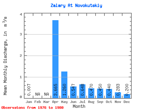
| Statistic | Jan | Feb | Mar | Apr | May | Jun | Jul | Aug | Sep | Oct | Nov | Dec | Annual |
|---|---|---|---|---|---|---|---|---|---|---|---|---|---|
| Mean | 0.01 | 3.67 | 1.26 | 0.55 | 0.65 | 0.47 | 0.45 | 0.44 | 0.28 | 0.20 | |||
| Standard Deviation | 2.91 | 0.69 | 0.22 | 0.23 | 0.09 | 0.07 | 0.19 | 0.17 | 0.09 | ||||
| Min | 0.01 | 1.51 | 0.77 | 0.41 | 0.46 | 0.41 | 0.36 | 0.26 | 0.04 | 0.10 | |||
| Max | 0.01 | 7.84 | 2.25 | 0.88 | 0.96 | 0.57 | 0.52 | 0.69 | 0.42 | 0.27 | |||
| Coefficient of Variation | 0.80 | 0.55 | 0.41 | 0.35 | 0.18 | 0.16 | 0.42 | 0.59 | 0.44 |
 Return to R-Arctic Net Home Page