|
|
|||||||||||||||||
| Point ID: 6526 | Downloads | Plots | Site Data | Code: 8366 |
|
|
|||||||||||||||||
| Download | |
|---|---|
| Site Descriptor Information | Site Time Series Data |
| Link to all available data | |
| View: | Time Series | All |
| Units: | m3/s |
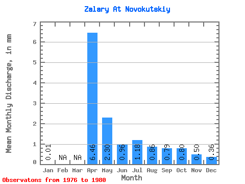
| Statistic | Jan | Feb | Mar | Apr | May | Jun | Jul | Aug | Sep | Oct | Nov | Dec | Annual |
|---|---|---|---|---|---|---|---|---|---|---|---|---|---|
| Mean | 0.01 | 6.46 | 2.29 | 0.96 | 1.18 | 0.86 | 0.79 | 0.80 | 0.50 | 0.36 | |||
| Standard Deviation | 5.14 | 1.27 | 0.39 | 0.42 | 0.16 | 0.13 | 0.34 | 0.30 | 0.16 | ||||
| Min | 0.01 | 2.66 | 1.40 | 0.72 | 0.84 | 0.75 | 0.64 | 0.47 | 0.07 | 0.18 | |||
| Max | 0.01 | 13.82 | 4.10 | 1.55 | 1.75 | 1.04 | 0.92 | 1.26 | 0.74 | 0.49 | |||
| Coefficient of Variation | 0.80 | 0.55 | 0.41 | 0.35 | 0.18 | 0.16 | 0.42 | 0.59 | 0.44 |
 Return to R-Arctic Net Home Page