|
|
|||||||||||||||||
| Point ID: 652 | Downloads | Plots | Site Data | Code: 07BB011 |
|
|
|||||||||||||||||
| Download | |
|---|---|
| Site Descriptor Information | Site Time Series Data |
| Link to all available data | |
| View: | Time Series | All |
| Units: | mm |
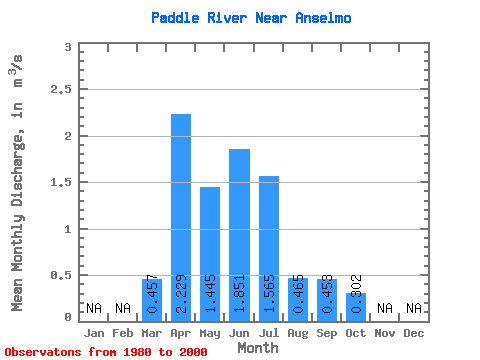
| Statistic | Jan | Feb | Mar | Apr | May | Jun | Jul | Aug | Sep | Oct | Nov | Dec | Annual |
|---|---|---|---|---|---|---|---|---|---|---|---|---|---|
| Mean | 0.46 | 2.23 | 1.45 | 1.85 | 1.56 | 0.47 | 0.45 | 0.30 | |||||
| Standard Deviation | 0.35 | 1.71 | 1.00 | 1.76 | 1.45 | 0.47 | 0.76 | 0.22 | |||||
| Min | 0.06 | 0.31 | 0.19 | 0.32 | 0.05 | 0.06 | 0.06 | 0.08 | |||||
| Max | 1.14 | 6.97 | 3.73 | 7.15 | 4.71 | 1.64 | 3.52 | 0.82 | |||||
| Coefficient of Variation | 0.77 | 0.77 | 0.69 | 0.95 | 0.93 | 1.00 | 1.68 | 0.73 |
 Return to R-Arctic Net Home Page