|
|
|||||||||||||||||
| Point ID: 652 | Downloads | Plots | Site Data | Code: 07BB011 |
|
|
|||||||||||||||||
| Download | |
|---|---|
| Site Descriptor Information | Site Time Series Data |
| Link to all available data | |
| View: | Time Series | All |
| Units: | m3/s |
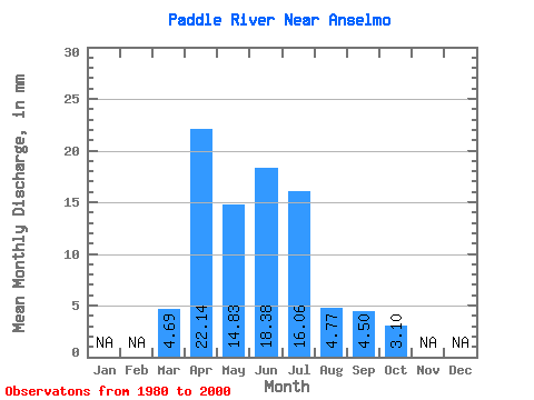
| Statistic | Jan | Feb | Mar | Apr | May | Jun | Jul | Aug | Sep | Oct | Nov | Dec | Annual |
|---|---|---|---|---|---|---|---|---|---|---|---|---|---|
| Mean | 4.69 | 22.14 | 14.83 | 18.38 | 16.06 | 4.78 | 4.50 | 3.09 | |||||
| Standard Deviation | 3.62 | 17.02 | 10.23 | 17.45 | 14.86 | 4.79 | 7.57 | 2.25 | |||||
| Min | 0.64 | 3.05 | 1.95 | 3.13 | 0.47 | 0.60 | 0.57 | 0.81 | |||||
| Max | 11.70 | 69.22 | 38.27 | 71.01 | 48.33 | 16.83 | 34.96 | 8.44 | |||||
| Coefficient of Variation | 0.77 | 0.77 | 0.69 | 0.95 | 0.93 | 1.00 | 1.68 | 0.73 |
 Return to R-Arctic Net Home Page