|
|
|||||||||||||||||
| Point ID: 6518 | Downloads | Plots | Site Data | Code: 8346 |
|
|
|||||||||||||||||
| Download | |
|---|---|
| Site Descriptor Information | Site Time Series Data |
| Link to all available data | |
| View: | Time Series | All |
| Units: | mm |
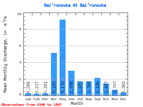
| Statistic | Jan | Feb | Mar | Apr | May | Jun | Jul | Aug | Sep | Oct | Nov | Dec | Annual |
|---|---|---|---|---|---|---|---|---|---|---|---|---|---|
| Mean | 0.27 | 0.22 | 0.26 | 5.16 | 9.17 | 3.00 | 1.70 | 1.70 | 2.14 | 1.44 | 0.71 | 0.36 | 2.08 |
| Standard Deviation | 0.14 | 0.10 | 0.12 | 4.74 | 4.48 | 1.28 | 0.81 | 1.77 | 2.33 | 0.88 | 0.40 | 0.20 | 0.55 |
| Min | 0.07 | 0.07 | 0.10 | 0.92 | 3.46 | 1.33 | 0.73 | 0.73 | 0.64 | 0.57 | 0.28 | 0.08 | 1.14 |
| Max | 0.55 | 0.47 | 0.58 | 18.70 | 19.80 | 6.98 | 3.94 | 8.94 | 8.57 | 3.73 | 1.89 | 0.80 | 3.03 |
| Coefficient of Variation | 0.52 | 0.46 | 0.47 | 0.92 | 0.49 | 0.43 | 0.48 | 1.04 | 1.09 | 0.61 | 0.57 | 0.56 | 0.26 |
 Return to R-Arctic Net Home Page