|
|
|||||||||||||||||
| Point ID: 6518 | Downloads | Plots | Site Data | Code: 8346 |
|
|
|||||||||||||||||
| Download | |
|---|---|
| Site Descriptor Information | Site Time Series Data |
| Link to all available data | |
| View: | Time Series | All |
| Units: | m3/s |
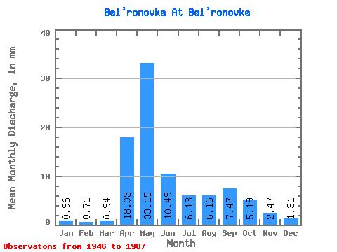
| Statistic | Jan | Feb | Mar | Apr | May | Jun | Jul | Aug | Sep | Oct | Nov | Dec | Annual |
|---|---|---|---|---|---|---|---|---|---|---|---|---|---|
| Mean | 0.96 | 0.72 | 0.94 | 18.03 | 33.14 | 10.49 | 6.13 | 6.16 | 7.47 | 5.19 | 2.48 | 1.31 | 88.68 |
| Standard Deviation | 0.50 | 0.33 | 0.45 | 16.59 | 16.18 | 4.48 | 2.94 | 6.38 | 8.15 | 3.17 | 1.41 | 0.73 | 23.23 |
| Min | 0.24 | 0.22 | 0.36 | 3.22 | 12.51 | 4.65 | 2.64 | 2.64 | 2.24 | 2.06 | 0.98 | 0.28 | 48.55 |
| Max | 1.99 | 1.55 | 2.10 | 65.41 | 71.56 | 24.42 | 14.24 | 32.31 | 29.98 | 13.48 | 6.61 | 2.89 | 129.05 |
| Coefficient of Variation | 0.52 | 0.46 | 0.47 | 0.92 | 0.49 | 0.43 | 0.48 | 1.04 | 1.09 | 0.61 | 0.57 | 0.56 | 0.26 |
 Return to R-Arctic Net Home Page