|
|
|||||||||||||||||
| Point ID: 6509 | Downloads | Plots | Site Data | Code: 8326 |
|
|
|||||||||||||||||
| Download | |
|---|---|
| Site Descriptor Information | Site Time Series Data |
| Link to all available data | |
| View: | Time Series | All |
| Units: | mm |
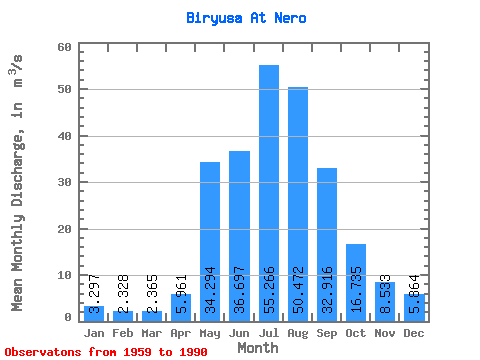
| Statistic | Jan | Feb | Mar | Apr | May | Jun | Jul | Aug | Sep | Oct | Nov | Dec | Annual |
|---|---|---|---|---|---|---|---|---|---|---|---|---|---|
| Mean | 3.30 | 2.33 | 2.37 | 5.96 | 34.29 | 36.70 | 55.27 | 50.47 | 32.92 | 16.73 | 8.53 | 5.86 | 21.29 |
| Standard Deviation | 1.07 | 0.69 | 0.81 | 3.26 | 16.30 | 15.74 | 23.46 | 17.34 | 10.88 | 4.66 | 2.17 | 1.83 | 4.68 |
| Min | 0.55 | 1.04 | 1.00 | 2.55 | 13.50 | 12.70 | 17.90 | 12.10 | 15.70 | 10.40 | 5.08 | 1.47 | 12.15 |
| Max | 5.73 | 4.41 | 4.66 | 14.60 | 86.90 | 76.90 | 122.00 | 96.30 | 62.80 | 29.50 | 13.30 | 9.10 | 33.86 |
| Coefficient of Variation | 0.32 | 0.29 | 0.34 | 0.55 | 0.47 | 0.43 | 0.42 | 0.34 | 0.33 | 0.28 | 0.25 | 0.31 | 0.22 |
 Return to R-Arctic Net Home Page