|
|
|||||||||||||||||
| Point ID: 6509 | Downloads | Plots | Site Data | Code: 8326 |
|
|
|||||||||||||||||
| Download | |
|---|---|
| Site Descriptor Information | Site Time Series Data |
| Link to all available data | |
| View: | Time Series | All |
| Units: | m3/s |
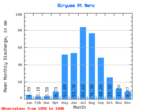
| Statistic | Jan | Feb | Mar | Apr | May | Jun | Jul | Aug | Sep | Oct | Nov | Dec | Annual |
|---|---|---|---|---|---|---|---|---|---|---|---|---|---|
| Mean | 4.99 | 3.21 | 3.58 | 8.73 | 51.89 | 53.74 | 83.62 | 76.36 | 48.20 | 25.32 | 12.50 | 8.87 | 379.57 |
| Standard Deviation | 1.61 | 0.95 | 1.22 | 4.77 | 24.66 | 23.04 | 35.50 | 26.23 | 15.94 | 7.04 | 3.17 | 2.77 | 83.46 |
| Min | 0.83 | 1.43 | 1.51 | 3.73 | 20.43 | 18.60 | 27.08 | 18.31 | 22.99 | 15.73 | 7.44 | 2.22 | 216.72 |
| Max | 8.67 | 6.08 | 7.05 | 21.38 | 131.48 | 112.61 | 184.59 | 145.70 | 91.97 | 44.63 | 19.48 | 13.77 | 603.71 |
| Coefficient of Variation | 0.32 | 0.29 | 0.34 | 0.55 | 0.47 | 0.43 | 0.42 | 0.34 | 0.33 | 0.28 | 0.25 | 0.31 | 0.22 |
 Return to R-Arctic Net Home Page