|
|
|||||||||||||||||
| Point ID: 6507 | Downloads | Plots | Site Data | Code: 8321 |
|
|
|||||||||||||||||
| Download | |
|---|---|
| Site Descriptor Information | Site Time Series Data |
| Link to all available data | |
| View: | Time Series | All |
| Units: | mm |
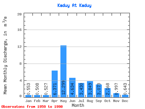
| Statistic | Jan | Feb | Mar | Apr | May | Jun | Jul | Aug | Sep | Oct | Nov | Dec | Annual |
|---|---|---|---|---|---|---|---|---|---|---|---|---|---|
| Mean | 0.55 | 0.51 | 0.53 | 6.37 | 12.30 | 4.63 | 3.43 | 3.85 | 3.07 | 2.17 | 1.00 | 0.64 | 3.35 |
| Standard Deviation | 0.20 | 0.17 | 0.19 | 5.31 | 7.69 | 2.58 | 2.12 | 3.40 | 2.14 | 1.02 | 0.37 | 0.28 | 1.13 |
| Min | 0.05 | 0.11 | 0.11 | 0.59 | 3.36 | 1.85 | 0.95 | 0.79 | 0.84 | 1.08 | 0.54 | 0.05 | 1.39 |
| Max | 0.95 | 0.75 | 1.05 | 21.90 | 33.10 | 11.10 | 9.83 | 14.60 | 9.43 | 5.76 | 2.28 | 1.60 | 5.92 |
| Coefficient of Variation | 0.35 | 0.33 | 0.35 | 0.83 | 0.62 | 0.56 | 0.62 | 0.88 | 0.70 | 0.47 | 0.37 | 0.43 | 0.34 |
 Return to R-Arctic Net Home Page