|
|
|||||||||||||||||
| Point ID: 6507 | Downloads | Plots | Site Data | Code: 8321 |
|
|
|||||||||||||||||
| Download | |
|---|---|
| Site Descriptor Information | Site Time Series Data |
| Link to all available data | |
| View: | Time Series | All |
| Units: | m3/s |
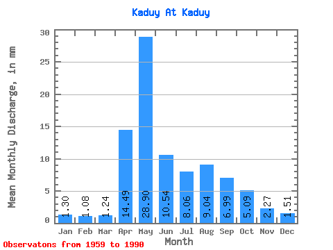
| Statistic | Jan | Feb | Mar | Apr | May | Jun | Jul | Aug | Sep | Oct | Nov | Dec | Annual |
|---|---|---|---|---|---|---|---|---|---|---|---|---|---|
| Mean | 1.30 | 1.09 | 1.24 | 14.49 | 28.89 | 10.54 | 8.06 | 9.04 | 6.99 | 5.09 | 2.27 | 1.51 | 92.76 |
| Standard Deviation | 0.46 | 0.36 | 0.44 | 12.07 | 18.07 | 5.86 | 4.97 | 7.99 | 4.88 | 2.41 | 0.84 | 0.66 | 31.38 |
| Min | 0.11 | 0.23 | 0.26 | 1.34 | 7.89 | 4.21 | 2.23 | 1.86 | 1.91 | 2.54 | 1.23 | 0.12 | 38.46 |
| Max | 2.23 | 1.60 | 2.47 | 49.79 | 77.76 | 25.24 | 23.09 | 34.30 | 21.44 | 13.53 | 5.18 | 3.76 | 164.03 |
| Coefficient of Variation | 0.35 | 0.33 | 0.35 | 0.83 | 0.62 | 0.56 | 0.62 | 0.88 | 0.70 | 0.47 | 0.37 | 0.43 | 0.34 |
 Return to R-Arctic Net Home Page