|
|
|||||||||||||||||
| Point ID: 6502 | Downloads | Plots | Site Data | Code: 8306 |
|
|
|||||||||||||||||
| Download | |
|---|---|
| Site Descriptor Information | Site Time Series Data |
| Link to all available data | |
| View: | Time Series | All |
| Units: | mm |
| Statistic | Jan | Feb | Mar | Apr | May | Jun | Jul | Aug | Sep | Oct | Nov | Dec | Annual |
|---|---|---|---|---|---|---|---|---|---|---|---|---|---|
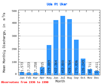
| Mean | 21.57 | 17.22 | 17.26 | 59.91 | 229.89 | 422.36 | 453.80 | 428.76 | 270.84 | 126.25 | 45.71 | 31.61 | 177.66 |
| Standard Deviation | 3.89 | 4.28 | 4.15 | 30.60 | 77.78 | 141.53 | 180.90 | 139.05 | 92.62 | 26.14 | 10.03 | 6.29 | 33.78 |
| Min | 8.44 | 9.74 | 11.60 | 18.90 | 116.00 | 235.00 | 209.00 | 206.00 | 140.00 | 81.80 | 24.40 | 14.50 | 118.00 |
| Max | 29.30 | 36.40 | 37.60 | 155.00 | 490.00 | 969.00 | 980.00 | 794.00 | 621.00 | 190.00 | 68.00 | 43.60 | 239.57 |
| Coefficient of Variation | 0.18 | 0.25 | 0.24 | 0.51 | 0.34 | 0.34 | 0.40 | 0.32 | 0.34 | 0.21 | 0.22 | 0.20 | 0.19 |
 Return to R-Arctic Net Home Page