|
|
|||||||||||||||||
| Point ID: 6502 | Downloads | Plots | Site Data | Code: 8306 |
|
|
|||||||||||||||||
| Download | |
|---|---|
| Site Descriptor Information | Site Time Series Data |
| Link to all available data | |
| View: | Time Series | All |
| Units: | m3/s |
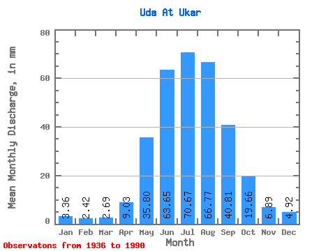
| Statistic | Jan | Feb | Mar | Apr | May | Jun | Jul | Aug | Sep | Oct | Nov | Dec | Annual |
|---|---|---|---|---|---|---|---|---|---|---|---|---|---|
| Mean | 3.36 | 2.44 | 2.69 | 9.03 | 35.79 | 63.65 | 70.66 | 66.76 | 40.81 | 19.66 | 6.89 | 4.92 | 325.99 |
| Standard Deviation | 0.61 | 0.61 | 0.65 | 4.61 | 12.11 | 21.33 | 28.16 | 21.65 | 13.96 | 4.07 | 1.51 | 0.98 | 61.98 |
| Min | 1.31 | 1.38 | 1.81 | 2.85 | 18.06 | 35.41 | 32.54 | 32.07 | 21.10 | 12.74 | 3.68 | 2.26 | 216.52 |
| Max | 4.56 | 5.16 | 5.85 | 23.36 | 76.29 | 146.03 | 152.58 | 123.62 | 93.58 | 29.58 | 10.25 | 6.79 | 439.59 |
| Coefficient of Variation | 0.18 | 0.25 | 0.24 | 0.51 | 0.34 | 0.34 | 0.40 | 0.32 | 0.34 | 0.21 | 0.22 | 0.20 | 0.19 |
 Return to R-Arctic Net Home Page