|
|
|||||||||||||||||
| Point ID: 6501 | Downloads | Plots | Site Data | Code: 8299 |
|
|
|||||||||||||||||
| Download | |
|---|---|
| Site Descriptor Information | Site Time Series Data |
| Link to all available data | |
| View: | Time Series | All |
| Units: | mm |
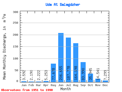
| Statistic | Jan | Feb | Mar | Apr | May | Jun | Jul | Aug | Sep | Oct | Nov | Dec | Annual |
|---|---|---|---|---|---|---|---|---|---|---|---|---|---|
| Mean | 3.59 | 2.19 | 2.22 | 5.25 | 77.68 | 206.66 | 187.78 | 164.20 | 83.99 | 35.95 | 14.54 | 7.30 | 65.94 |
| Standard Deviation | 0.98 | 0.64 | 0.71 | 3.03 | 37.04 | 58.29 | 62.15 | 50.77 | 23.16 | 7.14 | 3.00 | 1.43 | 10.65 |
| Min | 1.74 | 1.07 | 1.15 | 1.65 | 10.90 | 73.80 | 92.10 | 82.00 | 47.30 | 26.10 | 7.97 | 4.59 | 46.64 |
| Max | 6.09 | 3.47 | 4.04 | 12.80 | 204.00 | 364.00 | 349.00 | 297.00 | 149.00 | 66.70 | 20.80 | 10.80 | 84.95 |
| Coefficient of Variation | 0.27 | 0.29 | 0.32 | 0.58 | 0.48 | 0.28 | 0.33 | 0.31 | 0.28 | 0.20 | 0.21 | 0.20 | 0.16 |
 Return to R-Arctic Net Home Page