|
|
|||||||||||||||||
| Point ID: 6501 | Downloads | Plots | Site Data | Code: 8299 |
|
|
|||||||||||||||||
| Download | |
|---|---|
| Site Descriptor Information | Site Time Series Data |
| Link to all available data | |
| View: | Time Series | All |
| Units: | m3/s |
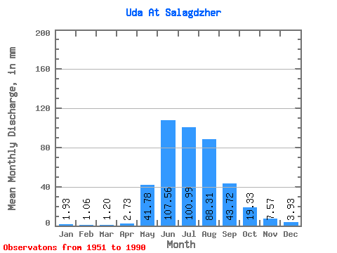
| Statistic | Jan | Feb | Mar | Apr | May | Jun | Jul | Aug | Sep | Oct | Nov | Dec | Annual |
|---|---|---|---|---|---|---|---|---|---|---|---|---|---|
| Mean | 1.93 | 1.07 | 1.20 | 2.73 | 41.77 | 107.56 | 100.98 | 88.30 | 43.72 | 19.33 | 7.57 | 3.92 | 417.92 |
| Standard Deviation | 0.53 | 0.31 | 0.38 | 1.58 | 19.92 | 30.34 | 33.42 | 27.30 | 12.06 | 3.84 | 1.56 | 0.77 | 67.52 |
| Min | 0.94 | 0.52 | 0.62 | 0.86 | 5.86 | 38.41 | 49.53 | 44.10 | 24.62 | 14.04 | 4.15 | 2.47 | 295.60 |
| Max | 3.27 | 1.70 | 2.17 | 6.66 | 109.70 | 189.46 | 187.68 | 159.71 | 77.55 | 35.87 | 10.83 | 5.81 | 538.35 |
| Coefficient of Variation | 0.27 | 0.29 | 0.32 | 0.58 | 0.48 | 0.28 | 0.33 | 0.31 | 0.28 | 0.20 | 0.21 | 0.20 | 0.16 |
 Return to R-Arctic Net Home Page