|
|
|||||||||||||||||
| Point ID: 6478 | Downloads | Plots | Site Data | Code: 8204 |
|
|
|||||||||||||||||
| Download | |
|---|---|
| Site Descriptor Information | Site Time Series Data |
| Link to all available data | |
| View: | Time Series | All |
| Units: | mm |
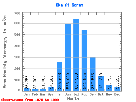
| Statistic | Jan | Feb | Mar | Apr | May | Jun | Jul | Aug | Sep | Oct | Nov | Dec | Annual |
|---|---|---|---|---|---|---|---|---|---|---|---|---|---|
| Mean | 26.26 | 22.30 | 21.07 | 34.56 | 256.69 | 593.00 | 637.56 | 541.88 | 297.56 | 131.31 | 56.76 | 33.56 | 221.04 |
| Standard Deviation | 9.05 | 4.63 | 3.83 | 12.79 | 98.82 | 118.05 | 197.59 | 167.31 | 88.44 | 33.36 | 12.62 | 10.43 | 37.33 |
| Min | 9.92 | 16.30 | 12.30 | 20.40 | 102.00 | 345.00 | 346.00 | 312.00 | 167.00 | 79.80 | 37.80 | 18.10 | 154.91 |
| Max | 50.10 | 35.10 | 26.50 | 67.20 | 441.00 | 762.00 | 1100.00 | 841.00 | 515.00 | 193.00 | 81.10 | 61.50 | 274.10 |
| Coefficient of Variation | 0.34 | 0.21 | 0.18 | 0.37 | 0.39 | 0.20 | 0.31 | 0.31 | 0.30 | 0.25 | 0.22 | 0.31 | 0.17 |
 Return to R-Arctic Net Home Page