|
|
|||||||||||||||||
| Point ID: 6478 | Downloads | Plots | Site Data | Code: 8204 |
|
|
|||||||||||||||||
| Download | |
|---|---|
| Site Descriptor Information | Site Time Series Data |
| Link to all available data | |
| View: | Time Series | All |
| Units: | m3/s |
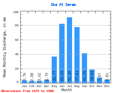
| Statistic | Jan | Feb | Mar | Apr | May | Jun | Jul | Aug | Sep | Oct | Nov | Dec | Annual |
|---|---|---|---|---|---|---|---|---|---|---|---|---|---|
| Mean | 3.76 | 2.91 | 3.02 | 4.79 | 36.76 | 82.20 | 91.30 | 77.60 | 41.24 | 18.80 | 7.87 | 4.81 | 373.05 |
| Standard Deviation | 1.30 | 0.60 | 0.55 | 1.77 | 14.15 | 16.36 | 28.30 | 23.96 | 12.26 | 4.78 | 1.75 | 1.49 | 63.00 |
| Min | 1.42 | 2.13 | 1.76 | 2.83 | 14.61 | 47.82 | 49.55 | 44.68 | 23.15 | 11.43 | 5.24 | 2.59 | 261.44 |
| Max | 7.17 | 4.58 | 3.79 | 9.31 | 63.16 | 105.62 | 157.53 | 120.44 | 71.38 | 27.64 | 11.24 | 8.81 | 462.60 |
| Coefficient of Variation | 0.34 | 0.21 | 0.18 | 0.37 | 0.39 | 0.20 | 0.31 | 0.31 | 0.30 | 0.25 | 0.22 | 0.31 | 0.17 |
 Return to R-Arctic Net Home Page