|
|
|||||||||||||||||
| Point ID: 6476 | Downloads | Plots | Site Data | Code: 8188 |
|
|
|||||||||||||||||
| Download | |
|---|---|
| Site Descriptor Information | Site Time Series Data |
| Link to all available data | |
| View: | Time Series | All |
| Units: | mm |
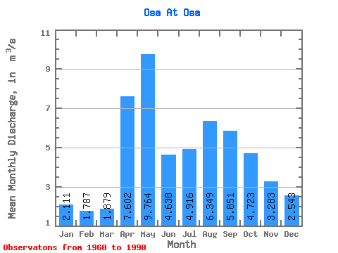
| Statistic | Jan | Feb | Mar | Apr | May | Jun | Jul | Aug | Sep | Oct | Nov | Dec | Annual |
|---|---|---|---|---|---|---|---|---|---|---|---|---|---|
| Mean | 2.11 | 1.79 | 1.88 | 7.60 | 9.76 | 4.64 | 4.92 | 6.35 | 5.85 | 4.72 | 3.28 | 2.54 | 4.60 |
| Standard Deviation | 0.78 | 0.64 | 0.68 | 3.78 | 5.64 | 1.74 | 2.04 | 3.67 | 2.85 | 1.82 | 1.37 | 0.92 | 1.46 |
| Min | 0.63 | 0.80 | 0.68 | 2.01 | 3.74 | 2.46 | 1.74 | 1.84 | 1.67 | 1.82 | 1.27 | 1.16 | 1.99 |
| Max | 3.46 | 3.09 | 3.52 | 18.00 | 24.00 | 9.78 | 10.00 | 18.80 | 14.10 | 8.72 | 6.60 | 4.23 | 8.66 |
| Coefficient of Variation | 0.37 | 0.36 | 0.36 | 0.50 | 0.58 | 0.38 | 0.42 | 0.58 | 0.49 | 0.39 | 0.42 | 0.36 | 0.32 |
 Return to R-Arctic Net Home Page