|
|
|||||||||||||||||
| Point ID: 6476 | Downloads | Plots | Site Data | Code: 8188 |
|
|
|||||||||||||||||
| Download | |
|---|---|
| Site Descriptor Information | Site Time Series Data |
| Link to all available data | |
| View: | Time Series | All |
| Units: | m3/s |
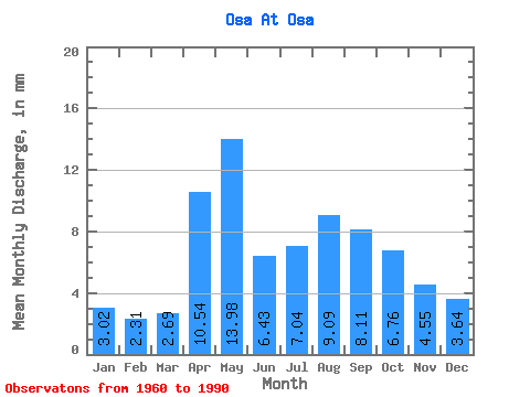
| Statistic | Jan | Feb | Mar | Apr | May | Jun | Jul | Aug | Sep | Oct | Nov | Dec | Annual |
|---|---|---|---|---|---|---|---|---|---|---|---|---|---|
| Mean | 3.02 | 2.33 | 2.69 | 10.54 | 13.98 | 6.43 | 7.04 | 9.09 | 8.11 | 6.76 | 4.55 | 3.64 | 77.65 |
| Standard Deviation | 1.12 | 0.83 | 0.98 | 5.24 | 8.07 | 2.42 | 2.93 | 5.25 | 3.95 | 2.61 | 1.90 | 1.32 | 24.65 |
| Min | 0.90 | 1.04 | 0.97 | 2.79 | 5.36 | 3.41 | 2.49 | 2.63 | 2.31 | 2.61 | 1.76 | 1.66 | 33.53 |
| Max | 4.96 | 4.03 | 5.04 | 24.95 | 34.37 | 13.56 | 14.32 | 26.92 | 19.54 | 12.49 | 9.15 | 6.06 | 146.20 |
| Coefficient of Variation | 0.37 | 0.36 | 0.36 | 0.50 | 0.58 | 0.38 | 0.42 | 0.58 | 0.49 | 0.39 | 0.42 | 0.36 | 0.32 |
 Return to R-Arctic Net Home Page