|
|
|||||||||||||||||
| Point ID: 647 | Downloads | Plots | Site Data | Code: 07BB004 |
|
|
|||||||||||||||||
| Download | |
|---|---|
| Site Descriptor Information | Site Time Series Data |
| Link to all available data | |
| View: | Time Series | All |
| Units: | mm |
| Statistic | Jan | Feb | Mar | Apr | May | Jun | Jul | Aug | Sep | Oct | Nov | Dec | Annual |
|---|---|---|---|---|---|---|---|---|---|---|---|---|---|
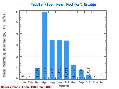
| Mean | 1.03 | 5.88 | 3.46 | 3.45 | 3.38 | 1.24 | 0.81 | 0.42 | |||||
| Standard Deviation | 1.24 | 5.66 | 3.30 | 4.03 | 3.86 | 3.08 | 1.10 | 0.47 | |||||
| Min | 0.01 | 0.00 | 0.03 | 0.25 | 0.04 | 0.02 | 0.00 | 0.01 | |||||
| Max | 4.41 | 28.10 | 14.70 | 19.30 | 20.00 | 19.20 | 5.01 | 2.40 | |||||
| Coefficient of Variation | 1.20 | 0.96 | 0.95 | 1.17 | 1.14 | 2.48 | 1.35 | 1.12 |
 Return to R-Arctic Net Home Page