|
|
|||||||||||||||||
| Point ID: 647 | Downloads | Plots | Site Data | Code: 07BB004 |
|
|
|||||||||||||||||
| Download | |
|---|---|
| Site Descriptor Information | Site Time Series Data |
| Link to all available data | |
| View: | Time Series | All |
| Units: | m3/s |
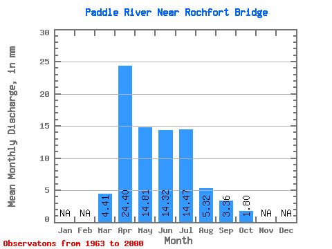
| Statistic | Jan | Feb | Mar | Apr | May | Jun | Jul | Aug | Sep | Oct | Nov | Dec | Annual |
|---|---|---|---|---|---|---|---|---|---|---|---|---|---|
| Mean | 4.41 | 24.40 | 14.81 | 14.32 | 14.47 | 5.32 | 3.36 | 1.80 | |||||
| Standard Deviation | 5.30 | 23.48 | 14.13 | 16.73 | 16.55 | 13.18 | 4.55 | 2.02 | |||||
| Min | 0.03 | 0.00 | 0.12 | 1.03 | 0.15 | 0.09 | 0.01 | 0.03 | |||||
| Max | 18.90 | 116.54 | 62.99 | 80.04 | 85.70 | 82.27 | 20.78 | 10.28 | |||||
| Coefficient of Variation | 1.20 | 0.96 | 0.95 | 1.17 | 1.14 | 2.48 | 1.35 | 1.12 |
 Return to R-Arctic Net Home Page