|
|
|||||||||||||||||
| Point ID: 6464 | Downloads | Plots | Site Data | Code: 8140 |
|
|
|||||||||||||||||
| Download | |
|---|---|
| Site Descriptor Information | Site Time Series Data |
| Link to all available data | |
| View: | Time Series | All |
| Units: | mm |
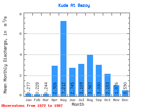
| Statistic | Jan | Feb | Mar | Apr | May | Jun | Jul | Aug | Sep | Oct | Nov | Dec | Annual |
|---|---|---|---|---|---|---|---|---|---|---|---|---|---|
| Mean | 0.28 | 0.23 | 0.24 | 2.93 | 7.21 | 2.75 | 3.11 | 3.99 | 3.03 | 2.15 | 1.08 | 0.59 | 2.96 |
| Standard Deviation | 0.33 | 0.33 | 0.26 | 1.81 | 4.31 | 2.48 | 2.23 | 2.98 | 2.57 | 1.64 | 0.86 | 0.54 | 1.43 |
| Min | 0.00 | 0.00 | 0.00 | 0.42 | 2.01 | 0.80 | 0.68 | 0.51 | 0.00 | 0.00 | 0.00 | 0.00 | 1.11 |
| Max | 1.16 | 0.86 | 0.67 | 6.66 | 15.10 | 10.60 | 8.23 | 9.67 | 7.49 | 5.02 | 2.69 | 1.69 | 4.34 |
| Coefficient of Variation | 1.19 | 1.42 | 1.06 | 0.62 | 0.60 | 0.90 | 0.72 | 0.75 | 0.85 | 0.76 | 0.80 | 0.91 | 0.48 |
 Return to R-Arctic Net Home Page