|
|
|||||||||||||||||
| Point ID: 6464 | Downloads | Plots | Site Data | Code: 8140 |
|
|
|||||||||||||||||
| Download | |
|---|---|
| Site Descriptor Information | Site Time Series Data |
| Link to all available data | |
| View: | Time Series | All |
| Units: | m3/s |
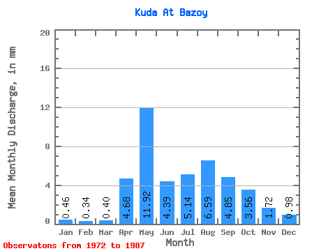
| Statistic | Jan | Feb | Mar | Apr | May | Jun | Jul | Aug | Sep | Oct | Nov | Dec | Annual |
|---|---|---|---|---|---|---|---|---|---|---|---|---|---|
| Mean | 0.46 | 0.34 | 0.40 | 4.68 | 11.92 | 4.39 | 5.14 | 6.59 | 4.85 | 3.56 | 1.72 | 0.97 | 57.72 |
| Standard Deviation | 0.55 | 0.49 | 0.43 | 2.89 | 7.13 | 3.97 | 3.69 | 4.93 | 4.11 | 2.71 | 1.38 | 0.89 | 27.83 |
| Min | 0.00 | 0.00 | 0.00 | 0.67 | 3.32 | 1.28 | 1.12 | 0.84 | 0.00 | 0.00 | 0.00 | 0.00 | 21.64 |
| Max | 1.92 | 1.29 | 1.11 | 10.66 | 24.96 | 16.96 | 13.61 | 15.98 | 11.98 | 8.30 | 4.30 | 2.79 | 84.60 |
| Coefficient of Variation | 1.19 | 1.42 | 1.06 | 0.62 | 0.60 | 0.90 | 0.72 | 0.75 | 0.85 | 0.76 | 0.80 | 0.91 | 0.48 |
 Return to R-Arctic Net Home Page