|
|
|||||||||||||||||
| Point ID: 6462 | Downloads | Plots | Site Data | Code: 8099 |
|
|
|||||||||||||||||
| Download | |
|---|---|
| Site Descriptor Information | Site Time Series Data |
| Link to all available data | |
| View: | Time Series | All |
| Units: | mm |
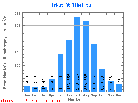
| Statistic | Jan | Feb | Mar | Apr | May | Jun | Jul | Aug | Sep | Oct | Nov | Dec | Annual |
|---|---|---|---|---|---|---|---|---|---|---|---|---|---|
| Mean | 20.48 | 17.36 | 18.40 | 48.48 | 144.28 | 193.56 | 279.92 | 266.89 | 180.86 | 85.08 | 41.00 | 28.72 | 110.46 |
| Standard Deviation | 5.87 | 5.01 | 5.54 | 15.61 | 40.91 | 62.27 | 99.99 | 79.91 | 53.79 | 13.98 | 11.44 | 8.43 | 18.94 |
| Min | 12.10 | 9.75 | 8.49 | 20.30 | 73.80 | 103.00 | 139.00 | 154.00 | 117.00 | 60.40 | 20.10 | 14.40 | 79.21 |
| Max | 33.70 | 29.50 | 31.70 | 85.30 | 267.00 | 318.00 | 547.00 | 486.00 | 307.00 | 120.00 | 79.80 | 54.30 | 147.49 |
| Coefficient of Variation | 0.29 | 0.29 | 0.30 | 0.32 | 0.28 | 0.32 | 0.36 | 0.30 | 0.30 | 0.16 | 0.28 | 0.29 | 0.17 |
 Return to R-Arctic Net Home Page