|
|
|||||||||||||||||
| Point ID: 6462 | Downloads | Plots | Site Data | Code: 8099 |
|
|
|||||||||||||||||
| Download | |
|---|---|
| Site Descriptor Information | Site Time Series Data |
| Link to all available data | |
| View: | Time Series | All |
| Units: | m3/s |
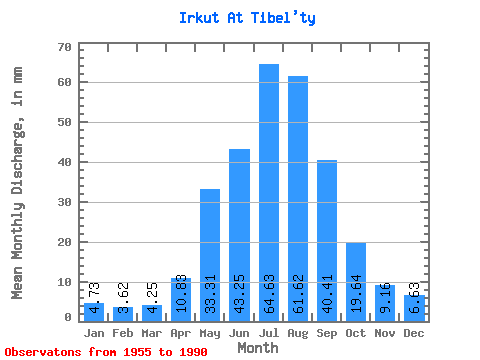
| Statistic | Jan | Feb | Mar | Apr | May | Jun | Jul | Aug | Sep | Oct | Nov | Dec | Annual |
|---|---|---|---|---|---|---|---|---|---|---|---|---|---|
| Mean | 4.73 | 3.65 | 4.25 | 10.83 | 33.31 | 43.25 | 64.62 | 61.62 | 40.41 | 19.64 | 9.16 | 6.63 | 300.53 |
| Standard Deviation | 1.36 | 1.05 | 1.28 | 3.49 | 9.44 | 13.91 | 23.08 | 18.45 | 12.02 | 3.23 | 2.56 | 1.95 | 51.53 |
| Min | 2.79 | 2.05 | 1.96 | 4.54 | 17.04 | 23.02 | 32.09 | 35.55 | 26.14 | 13.94 | 4.49 | 3.32 | 215.50 |
| Max | 7.78 | 6.21 | 7.32 | 19.06 | 61.64 | 71.06 | 126.28 | 112.20 | 68.60 | 27.70 | 17.83 | 12.54 | 401.28 |
| Coefficient of Variation | 0.29 | 0.29 | 0.30 | 0.32 | 0.28 | 0.32 | 0.36 | 0.30 | 0.30 | 0.16 | 0.28 | 0.29 | 0.17 |
 Return to R-Arctic Net Home Page