|
|
|||||||||||||||||
| Point ID: 6437 | Downloads | Plots | Site Data | Code: 7124 |
|
|
|||||||||||||||||
| Download | |
|---|---|
| Site Descriptor Information | Site Time Series Data |
| Link to all available data | |
| View: | Time Series | All |
| Units: | mm |
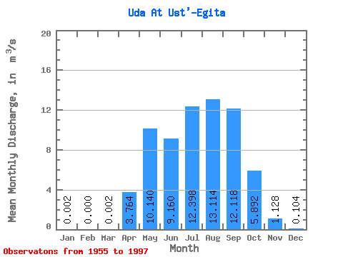
| Statistic | Jan | Feb | Mar | Apr | May | Jun | Jul | Aug | Sep | Oct | Nov | Dec | Annual |
|---|---|---|---|---|---|---|---|---|---|---|---|---|---|
| Mean | 0.00 | 0.00 | 0.00 | 3.76 | 10.14 | 9.16 | 12.40 | 13.11 | 12.12 | 5.89 | 1.13 | 0.10 | 5.74 |
| Standard Deviation | 0.01 | 0.00 | 0.01 | 4.35 | 9.73 | 12.79 | 15.77 | 15.83 | 11.47 | 4.59 | 0.89 | 0.13 | 4.34 |
| Min | 0.00 | 0.00 | 0.00 | 0.09 | 1.12 | 0.35 | 0.69 | 0.67 | 0.82 | 0.73 | 0.09 | 0.00 | 0.72 |
| Max | 0.05 | 0.00 | 0.04 | 16.10 | 44.60 | 61.90 | 61.60 | 71.80 | 39.40 | 17.40 | 3.53 | 0.48 | 21.09 |
| Coefficient of Variation | 4.92 | 4.49 | 1.16 | 0.96 | 1.40 | 1.27 | 1.21 | 0.95 | 0.78 | 0.79 | 1.21 | 0.76 |
 Return to R-Arctic Net Home Page