|
|
|||||||||||||||||
| Point ID: 6437 | Downloads | Plots | Site Data | Code: 7124 |
|
|
|||||||||||||||||
| Download | |
|---|---|
| Site Descriptor Information | Site Time Series Data |
| Link to all available data | |
| View: | Time Series | All |
| Units: | m3/s |
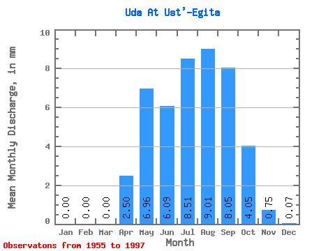
| Statistic | Jan | Feb | Mar | Apr | May | Jun | Jul | Aug | Sep | Oct | Nov | Dec | Annual |
|---|---|---|---|---|---|---|---|---|---|---|---|---|---|
| Mean | 0.00 | 0.00 | 0.00 | 2.50 | 6.96 | 6.09 | 8.51 | 9.01 | 8.05 | 4.05 | 0.75 | 0.07 | 46.43 |
| Standard Deviation | 0.01 | 0.00 | 0.01 | 2.89 | 6.69 | 8.50 | 10.83 | 10.87 | 7.62 | 3.15 | 0.59 | 0.09 | 35.09 |
| Min | 0.00 | 0.00 | 0.00 | 0.06 | 0.77 | 0.23 | 0.47 | 0.46 | 0.55 | 0.50 | 0.06 | 0.00 | 5.81 |
| Max | 0.04 | 0.00 | 0.03 | 10.70 | 30.62 | 41.14 | 42.30 | 49.30 | 26.19 | 11.95 | 2.35 | 0.33 | 170.67 |
| Coefficient of Variation | 4.92 | 4.49 | 1.16 | 0.96 | 1.40 | 1.27 | 1.21 | 0.95 | 0.78 | 0.79 | 1.21 | 0.76 |
 Return to R-Arctic Net Home Page