|
|
|||||||||||||||||
| Point ID: 6432 | Downloads | Plots | Site Data | Code: 7109 |
|
|
|||||||||||||||||
| Download | |
|---|---|
| Site Descriptor Information | Site Time Series Data |
| Link to all available data | |
| View: | Time Series | All |
| Units: | mm |
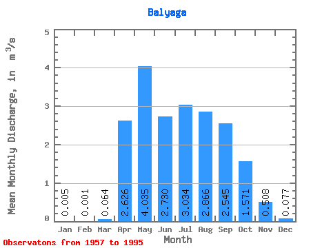
| Statistic | Jan | Feb | Mar | Apr | May | Jun | Jul | Aug | Sep | Oct | Nov | Dec | Annual |
|---|---|---|---|---|---|---|---|---|---|---|---|---|---|
| Mean | 0.01 | 0.00 | 0.06 | 2.63 | 4.04 | 2.73 | 3.03 | 2.87 | 2.54 | 1.57 | 0.51 | 0.08 | 1.69 |
| Standard Deviation | 0.02 | 0.00 | 0.10 | 1.79 | 2.15 | 2.03 | 2.53 | 2.05 | 1.81 | 1.15 | 0.41 | 0.14 | 0.77 |
| Min | 0.00 | 0.00 | 0.00 | 0.55 | 1.26 | 0.67 | 0.63 | 0.44 | 0.40 | 0.31 | 0.06 | 0.00 | 0.53 |
| Max | 0.10 | 0.02 | 0.39 | 7.56 | 8.44 | 9.80 | 12.60 | 8.72 | 9.06 | 6.91 | 2.26 | 0.62 | 3.53 |
| Coefficient of Variation | 3.61 | 6.16 | 1.64 | 0.68 | 0.53 | 0.74 | 0.83 | 0.71 | 0.71 | 0.73 | 0.80 | 1.80 | 0.46 |
 Return to R-Arctic Net Home Page