|
|
|||||||||||||||||
| Point ID: 6432 | Downloads | Plots | Site Data | Code: 7109 |
|
|
|||||||||||||||||
| Download | |
|---|---|
| Site Descriptor Information | Site Time Series Data |
| Link to all available data | |
| View: | Time Series | All |
| Units: | m3/s |
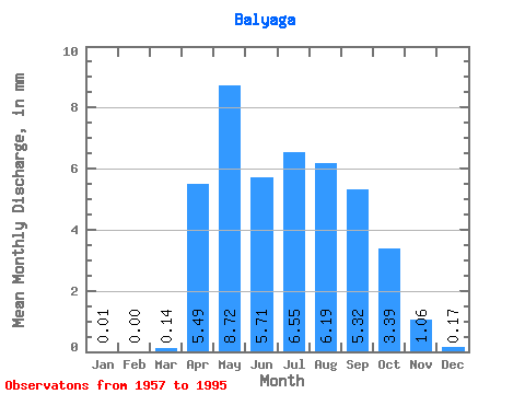
| Statistic | Jan | Feb | Mar | Apr | May | Jun | Jul | Aug | Sep | Oct | Nov | Dec | Annual |
|---|---|---|---|---|---|---|---|---|---|---|---|---|---|
| Mean | 0.01 | 0.00 | 0.14 | 5.49 | 8.71 | 5.71 | 6.55 | 6.19 | 5.32 | 3.39 | 1.06 | 0.17 | 42.95 |
| Standard Deviation | 0.04 | 0.01 | 0.23 | 3.74 | 4.64 | 4.24 | 5.46 | 4.42 | 3.77 | 2.48 | 0.85 | 0.30 | 19.69 |
| Min | 0.00 | 0.00 | 0.00 | 1.15 | 2.72 | 1.40 | 1.36 | 0.95 | 0.84 | 0.67 | 0.12 | 0.00 | 13.40 |
| Max | 0.22 | 0.04 | 0.84 | 15.80 | 18.23 | 20.48 | 27.21 | 18.83 | 18.94 | 14.92 | 4.72 | 1.34 | 89.77 |
| Coefficient of Variation | 3.61 | 6.16 | 1.64 | 0.68 | 0.53 | 0.74 | 0.83 | 0.71 | 0.71 | 0.73 | 0.80 | 1.80 | 0.46 |
 Return to R-Arctic Net Home Page