|
|
|||||||||||||||||
| Point ID: 6429 | Downloads | Plots | Site Data | Code: 7099 |
|
|
|||||||||||||||||
| Download | |
|---|---|
| Site Descriptor Information | Site Time Series Data |
| Link to all available data | |
| View: | Time Series | All |
| Units: | mm |
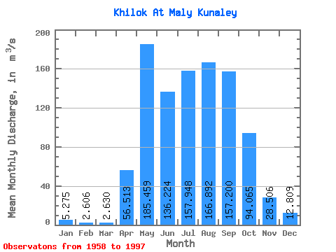
| Statistic | Jan | Feb | Mar | Apr | May | Jun | Jul | Aug | Sep | Oct | Nov | Dec | Annual |
|---|---|---|---|---|---|---|---|---|---|---|---|---|---|
| Mean | 5.28 | 2.61 | 2.63 | 56.51 | 185.46 | 136.22 | 157.95 | 166.89 | 157.20 | 94.06 | 28.51 | 12.81 | 84.74 |
| Standard Deviation | 4.49 | 2.32 | 2.23 | 30.72 | 90.53 | 85.18 | 99.79 | 105.61 | 109.95 | 56.65 | 15.35 | 8.86 | 33.47 |
| Min | 0.31 | 0.01 | 0.09 | 4.89 | 65.40 | 9.95 | 38.20 | 34.10 | 34.60 | 22.70 | 3.92 | 1.85 | 30.64 |
| Max | 17.20 | 7.84 | 7.67 | 152.00 | 433.00 | 411.00 | 432.00 | 413.00 | 488.00 | 304.00 | 68.60 | 35.10 | 150.75 |
| Coefficient of Variation | 0.85 | 0.89 | 0.85 | 0.54 | 0.49 | 0.62 | 0.63 | 0.63 | 0.70 | 0.60 | 0.54 | 0.69 | 0.40 |
 Return to R-Arctic Net Home Page