|
|
|||||||||||||||||
| Point ID: 6428 | Downloads | Plots | Site Data | Code: 7098 |
|
|
|||||||||||||||||
| Download | |
|---|---|
| Site Descriptor Information | Site Time Series Data |
| Link to all available data | |
| View: | Time Series | All |
| Units: | mm |
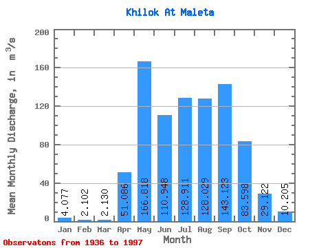
| Statistic | Jan | Feb | Mar | Apr | May | Jun | Jul | Aug | Sep | Oct | Nov | Dec | Annual |
|---|---|---|---|---|---|---|---|---|---|---|---|---|---|
| Mean | 4.08 | 2.10 | 2.13 | 51.09 | 166.82 | 110.95 | 128.91 | 128.03 | 143.12 | 83.60 | 29.12 | 10.21 | 73.16 |
| Standard Deviation | 3.47 | 1.78 | 1.81 | 35.26 | 83.49 | 70.84 | 88.53 | 78.00 | 108.42 | 50.56 | 39.50 | 7.02 | 29.85 |
| Min | 0.03 | 0.00 | 0.00 | 2.45 | 42.10 | 8.31 | 22.70 | 18.70 | 17.10 | 14.50 | 3.61 | 0.35 | 18.10 |
| Max | 15.00 | 7.27 | 7.78 | 165.00 | 388.00 | 372.00 | 422.00 | 382.00 | 519.00 | 249.00 | 316.00 | 31.30 | 133.16 |
| Coefficient of Variation | 0.85 | 0.84 | 0.85 | 0.69 | 0.50 | 0.64 | 0.69 | 0.61 | 0.76 | 0.60 | 1.36 | 0.69 | 0.41 |
 Return to R-Arctic Net Home Page